A judge in Utah has added a new wrinkle to this year’s mid-decade redistricting fight, overturning a Republican-drawn congressional map:
The Utah Legislature violated voters’ rights by approving congressional boundaries that split Salt Lake County, Third District Court Judge Dianna Gibson ruled.
The overturned map cleaved Salt Lake City into each of the state’s four districts, each of which elected a Republican. A Congressional map that keeps Salt Lake City whole would likely change the state’s congressional delegation from 4-0 to 3-1 Republican.
Democrats in Oregon similarly split Portland into four districts to advantage their party.
No matter the legality of carving up those cities in those states, it is better policy to keep the political communities of interest that cities represent together when possible.
Current North Carolina map keeps cities largely intact
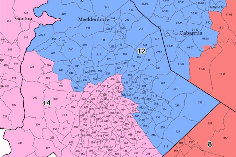
North Carolina is no stranger to seeing its cities cleaved apart to help one party in redistricting. The congressional map used here in 2022, drawn by court-appointed special masters, split Charlotte down the middle:
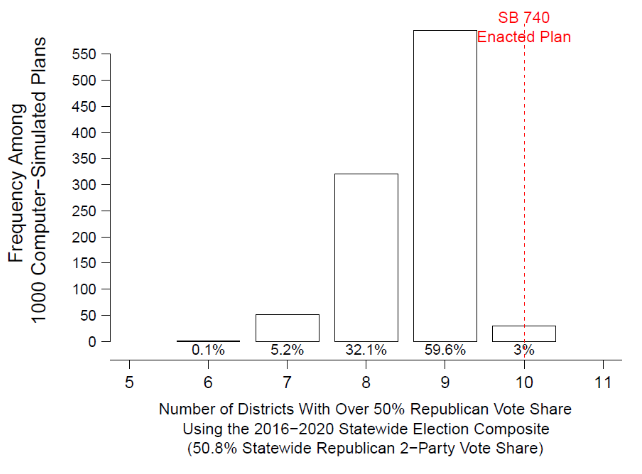
The result is a 7-7 map with only two competitive districts. That result is improbable in a map drawn using nonpartisan redistricting criteria. For example, Dr. Jowei Chen, a witness for the plaintiffs in the redistricting case, found only a 5.3% chance of getting an outcome so favorable to Democrats (see Figure 1).
What it does is protect Democrats from what is expected to be a Republican wave election this fall.
Figure 1: Likelihood of North Carolina congressional map outcomes by Dr. Jowei Chen. The chart is on page 33 of Chen’s report.
It is also easy to see the primary way Orr and the other special masters achieved that unlikely outcome. They took a meat cleaver to Charlotte, splitting the city down the middle. They then grafted half onto suburban Gaston County and the other half (along with most of suburban Mecklenburg County onto Cabarrus County. Their map does not even meet the minimum community of interest standard of having a congressional district wholly contained in Mecklenburg County.
The General Assembly drew a new congressional map before the 2024 election. While that map had problems, including a gratuitous three-way cleaving of Guilford County, it at least kept North Carolina’s major cities largely intake.
It is not too early to consider redistricting reform
Maintain current criteria from the North Carolina State Constitution. Those include equal population (with a small permitted variance for state legislative districts and an even smaller allowed variance for congressional districts), contiguity, and minimizing county traversals.
Do not use partisan data, such as voter registration and election results. Racial data is not necessary for compliance with the Voting Rights Act and should not be used, because there is some correlation between racial and partisan data. Do not consider incumbents’ addresses when drawing districts to avoid “double-bunking.”
When drawing maps, do not consider statewide measures, such as particular partisan balances or making more districts that are competitive. Instead, focus on measures that help solidify districts’ relationships with their local communities. Those include making districts compact, minimizing precinct (voting tabulation district) splits, and avoiding splitting municipalities within county boundaries. [emphasis added]
It is not too early to enact redistricting reform before the next reapportionment in 2031. In fact, it may be easier to enact reforms now when the outcome of the 2030 midterm elections are less certain.
This content is courtesy of, and owned and copyrighted by, https://www.johnlocke.org and its author. This content is made available by use of the public RSS feed offered by the host site and is used for educational purposes only. If you are the author or represent the host site and would like this content removed now and in the future, please contact USSANews.com using the email address in the Contact page found in the website menu.