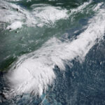
Storm surge flooding and tropical storm conditions from Hurricane Erin are forecast for the Outer Banks of North Carolina starting Wednesday evening.
At 5 p.m., Erin was packing maximum sustained winds of 105 mph. The Category 2 hurricane remains on a path to steer clear of the United States mainland, though it is already brushing in large waves and will bring beach erosion and overwash.
The storm was 615 miles south-southeast of Cape Hatteras and 615 miles southwest of Bermuda, moving at 10 mph. Storm surge warnings were in effect from Cape Lookout to Duck; a tropical storm warning was in effect from Beaufort Inlet to Duck, inclusive of the Pamlico and Albemarle sounds; and a tropical storm watch was in effect from north of Duck to Chincoteague, Va.
Intensity of the storm is forecast to fluctuate. Hurricane force winds, meaning 74 mph or greater, stayed extended 80 miles from its center throughout Tuesday; tropical storm-force winds, meaning 39 mph or greater, grew to 230 miles from the center.
Click this link for the original source of this article.
Author: Ray Hilbrich
This content is courtesy of, and owned and copyrighted by, https://www.offthepress.com and its author. This content is made available by use of the public RSS feed offered by the host site and is used for educational purposes only. If you are the author or represent the host site and would like this content removed now and in the future, please contact USSANews.com using the email address in the Contact page found in the website menu.


