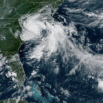

Tropical Storm Chantal was downgraded to a depression Sunday but raised concerns of possible flash flooding as it makes its way into central and eastern North Carolina.
Chantal made landfall near Litchfield Beach, South Carolina, at about 4 a.m. EDT Sunday, the National Hurricane Center in Miami said. At 11 a.m., it was located about 80 miles (130 kilometers) west of Wilmington, North Carolina, and was moving north at 9 mph (14 kph) with maximum sustained winds of 35 mph (56 kph).
The system was expected to turn to the northeast late Sunday as it weakens further.

The hurricane center canceled tropical storm warnings for portions of the two Carolinas. But heavy rain was forecast for parts of North Carolina through Monday, with total rainfall of 2 to 4 inches (5 to 10 centimeters) and local amounts up to 6 inches (15 centimeters) that could lead to flash flooding.
Click this link for the original source of this article.
Author: Joe Weber

This content is courtesy of, and owned and copyrighted by, https://www.offthepress.com and its author. This content is made available by use of the public RSS feed offered by the host site and is used for educational purposes only. If you are the author or represent the host site and would like this content removed now and in the future, please contact USSANews.com using the email address in the Contact page found in the website menu.