Ever since the start of Joe Biden’s presidency, curbing climate change has been a fundamental component of his energy policy agenda.
During the spring, for example, the Biden administration issued a power plant rule, imposing strict emissions reductions regarding the use of fossil-fuel power plants. There have been many other rules proposed as well, including regulating cars, stoves, dishwashers, water heaters, and even microwaves.
All of these rules are predicated on concerns about the effects of greenhouse gas emissions on global temperatures and climate change. If greenhouse gas emissions drive climate change, then curbing the use of sources of energy that emit them (such as coal, oil, and natural gas) should in theory curb these increases in global temperature.

However, lawmakers often present policies aimed at curbing climate change only in terms of greenhouse-gas emissions reductions. For example, the recent rule the Biden administration issued on electric vehicles claims it will reduce greenhouse gases by 7.2 billion tons through 2055.
This figure sounds large, but it’s surprisingly deceptive: A key unanswered question is the actual temperature impact of these and other related policies.
The predicted temperature impact of these and other policies hinges on a number of assumptions that affect our ever-changing climate.

That’s why we have created The Heritage Foundation Climate Calculator, an online tool that enables the public to change some of the assumptions to simulate the climate effects of these policies to reduce carbon emissions. (The libertarian Cato Institute had a similar tool in the 2010s.)
[Use The Heritage Foundation Climate Calculator]
The calculator is based on the Intergovernmental Panel on Climate Change’s Model for Assessment of Greenhouse Gas Induced Climate Change.
As the documentation illustrates, there are myriad assumptions regarding climate in this model. Our calculator focuses on allowing the user to play with two key assumptions:
- Climate sensitivity
- Level of emissions reduction
Scientists generally agree that the earth warms as carbon dioxide emissions increase. The real question, then, is to what degree (no pun intended).

Climate sensitivity measures how much the earth’s temperature will warm as a result of a doubling of atmospheric carbon dioxide concentration. Climate scientists’ estimates of climate sensitivity vary greatly, partly because the physical interactions between carbon dioxide and temperatures are not fully understood.
The level of emissions reductions is the percentage of CO2 emissions that lawmakers would seek to reduce with respect to current emissions. The methodology explained below contains full details.
The simulations presented in this calculator allow user-selected climate sensitivities between 2? and 5?, stated as the “very likely” range of climate sensitivity, according the IPCC’s Sixth Assessment Report, encompassing the “likely” range of 2.5? to 4?.
Although empirical evidence comparing observations to predictions suggests that sensitivities toward the lower end of these ranges may indeed be more plausible, The Heritage Foundation Climate Calculator allows users to decide which climate sensitivity they would like to assume and how steep the reductions in fossil fuel use they’d like to see.
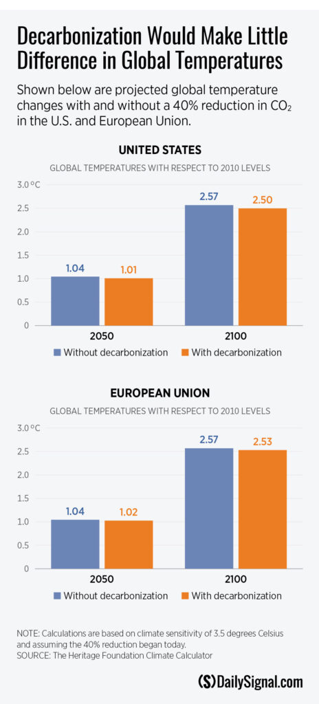
For example, what if lawmakers wanted to reduce carbon emissions by 40% starting this year? Assuming a 3-degree sensitivity (the middle of the IPCC’s range of sensitivities), there would be about a 0.036 degree Celsius reduction by 2050 and 0.070 degree Celsius decline by 2100.
What about the European Union, again assuming 3.5 degree Celsius sensitivity and 40% reductions? It’s even more trifling—less than 0.019 degree Celsius temperature reduction by 2050 and 0.037 degree Celsius temperature decline in 2100.
Even assuming the most aggressive policy imaginable (100% reductions) and the IPCC’s worst-case scenario regarding climate sensitivity (5 degrees sensitivity), The Heritage Foundation Climate Calculator shows that if the U.S. were to completely eliminate use of fossil fuels, there would be less than 0.23 degree Celsius global temperature reduction by 2100.
If the EU were to do so, the impact would be even more trifling—less than 0.13 degree Celsius global temperature reduction.
These are just a few of the scenarios that one can simulate using The Heritage Foundation Climate Calculator.
[Use The Heritage Foundation Climate Calculator]
We encourage you to play with the calculator and tweak assumptions yourself. The results will speak for themselves: Regardless of the assumptions made using this government model, the climate effects of carbon reduction policies are slim to none.
Don’t be deceived: Emissions reductions that lawmakers claim to be large in quantity will fail to produce meaningful temperature reductions and strengthen China, while Beijing continues to pump out greenhouse gases in much larger quantities than the rest of the world.
The post See for Yourself: Interactive Calculator Shows How Cutting Carbon Emissions Would Barely Budge Temperatures appeared first on The Daily Signal.
Click this link for the original source of this article.
Author: Kevin Dayaratna
This content is courtesy of, and owned and copyrighted by, http://dailysignal.com/ and its author. This content is made available by use of the public RSS feed offered by the host site and is used for educational purposes only. If you are the author or represent the host site and would like this content removed now and in the future, please contact USSANews.com using the email address in the Contact page found in the website menu.